Cambridge Alums in Path of Hurricane Matthew Describe Day of Chaos
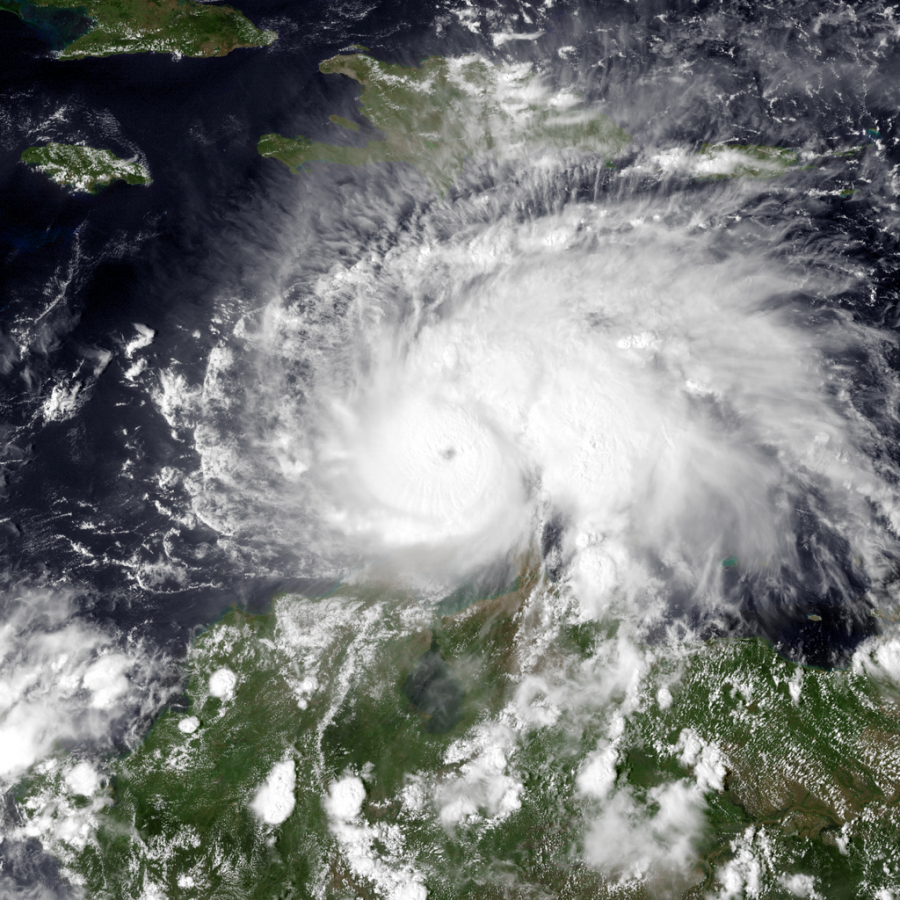
Hurricane Matthew rapidly intensifying north of Colombia late on Sept 30.
College freshman Alissa Garguilo described leaving her dorm as Hurricane Matthew headed in her direction as “a mad scramble.”
“The school told everyone to empty their fridges and unplug everything in their rooms,” said Garguilo, a 2016 Cambridge alumna now studying at Stetson University in DeLand, Florida. She said that on Oct. 4, when students were told to evacuate the campus, “everyone was scrambling to find a place to go.”
“I had just gone grocery shopping and we had to empty our fridges, so I was giving all my food away to people who lived closer by,” Garguilo said.
Hours earlier, it had been a completely normal day for Garguilo. She had her backpack packed and was ready to go to class at noon.
But before she could get there, all classes were canceled. A mass email was sent out by her school telling all the students to evacuate in the middle of the day.
Hurricane Matthew was on its way.
Garguilo flew out of Florida on Wednesday morning at 5:45. Before she got to the airport, the effects of the hurricane were already apparent.
“The lines for gas were super long. A lot of the gas pumps had tape over them because all the gas stations were out of gas. At the airport, all the shops were closed down,” said Garguilo.
Based off of reports from the Weather Channel website, Hurricane Matthew formed from a tropical wave pushed off the African coast in late September. By October 1st, the storm reached Category 5 strength and had reached the eastern Caribbean coast.
The National Hurricane Center describes a Category 5 hurricane as having winds of 157 miles per hour or higher. The Saffir-Simpson Hurricane Wind Scale says most of the area affected by a storm of this magnitude would be uninhabitable for weeks or months.
But shortly after Matthew reached a Category 5, it fell back down to a Category 4 and then a Category 3. By the time the storm made official U.S landfall in McClellanville, S.C. on Saturday morning, it was down to a Category 1, which includes winds between 74 and 95 miles per hour.
The coasts of Florida, Georgia, South Carolina and North Carolina were hit hard by winds and rains from the storm but weren’t directly hit by the hurricane. Still, over a million people were left without power.
“The storm ended up barely even hitting us and it wasn’t bad at all,” said 2016 Cambridge alumna and University of Miami freshman Heather Deas.
“The dorms we live in are hurricane proof and they made it through Hurricane Andrew, so we’d only have to evacuate if it was a Category 4. We were pretty much locked on our floor all day [Thursday] because elevators were closed and our stairs are outside so we couldn’t use them,” said Deas.
At Savannah College of Art and Design, the student body was forced to evacuate and take buses to the SCAD campus in Atlanta.
“They canceled our classes Wednesday through Monday and I evacuated back home on Wednesday,” said 2016 Cambridge alumna and SCAD freshman Kat Dezell.
According to an article from the Savannah Now website, Goldman Sachs estimates the damages from Matthew could cost up to $10 billion dollars nationally. This figure is relatively minimal compared to costs of damages for storms like Hurricane Sandy in 2012, which caused between $50 and $60 billion dollars in damages.
By Monday, Hurricane Matthew had dissipated. However, many cities were affected by flooding in the aftermath of the storm.
Brantley is a senior, and has been staff at The Bear Witness for two years.